


Tintagel is one of those places where history and legend are tightly intertwined. Set on the dramatic headland beside the village once known as Trevena, it is now most famous for the ruined medieval castle built in the 13th century by Richard, Earl of Cornwall. Yet the story of Tintagel reaches far deeper than those broken walls. Finds from the Romano British period suggest activity in and around the site, even though no Roman building has yet been proven there. By the early medieval period, Tintagel appears to have become a place of real status, perhaps a seasonal residence of the rulers of Dumnonia, looking out over the Atlantic yet connected by trade to a much wider world. The archaeology has changed the way we understand Tintagel. Excavations in the 1930s first revealed traces of a far earlier settlement beneath the later castle, and later work has strengthened the sense that this was not an isolated cliff top refuge, but an elite centre with remarkable connections. Pottery, glass, amphora fragments and other imported objects show contact with Spain, North Africa, Gaul and the eastern Mediterranean. More recent digs uncovered the remains of substantial fifth and sixth century buildings, along with evidence of literacy, including inscribed slate. For a place often placed within the so called Dark Ages, Tintagel instead points towards a society that was wealthy, outward looking, and far more complex than the old phrase allows. Its Arthurian power comes largely through Geoffrey of Monmouth, who in the 12th century made Tintagel the place of Arthur’s conception in his Historia Regum Britanniae. In Geoffrey’s account, Uther Pendragon, aided by Merlin’s enchantment, takes on the likeness of Gorlois, Duke of Cornwall, and enters Tintagel to reach Igraine. Whether this tale preserves an older Cornish tradition or whether Geoffrey gave the landscape a new mythic force remains debated. There is no firm archaeological proof connecting Arthur himself to Tintagel, yet the deeper early medieval occupation gives the legend a powerful setting. The place was not invented from nothing. It already carried the weight of kingship, sea power, ritual memory and ancestral authority. Since the 19th century, Tintagel has drawn visitors through that mixture of ruin, cliff, story and atmosphere. The castle is now cared for by English Heritage, while the land remains part of the Duchy of Cornwall. Victorian fascination with Arthur helped turn the site into a place of pilgrimage, and modern additions such as the footbridge, the Gallos sculpture and the carving near Merlin’s Cave have continued to shape the experience, sometimes with controversy. Yet beneath all of that, the land itself remains the strongest presence and a symbol of Cornwall's history and mythology.


The Armed Knight is a rocky islet off Land’s End, on Cornwall’s far western coast. It rises from the sea near the Longships reef and lighthouse, forming one of the most recognisable features in the view from the cliffs. The rocks are part of a dramatic coastal landscape shaped by Atlantic weather, dangerous waters, and long maritime history. For visitors looking out from the headland, the Armed Knight marks the edge of land before the open ocean. The name is linked with an older landmark once known as Spire Rock, or Careg an Pell in Cornish, meaning the distant rock. This natural stone tower stood on or near the westernmost part of the headland and was remembered as a striking feature of the coast. Local tradition says that it survived until 1648, when a powerful storm broke it apart and sent it crashing into the sea. The later name “The Peal” may preserve an echo of this lost rock. The fall of Spire Rock became part of local historical memory. Some people later treated its destruction as a warning sign, especially because King Charles I was executed the following year in 1649. Stories also claimed that the rock had once carried an iron rod or spire, sometimes linked with the Romans or with King Athelstan. These claims cannot be proved, but they show how the landmark became associated with ideas of power, conquest, and warning. After Spire Rock disappeared, the name and meaning attached to it seem to have shifted to the offshore rocks now called the Armed Knight. Antiquarian writers also recorded traditions of a watchtower or sea mark at Land’s End, used by mariners navigating this dangerous coast. Whether these accounts refer to Spire Rock, another natural feature, or a built structure is uncertain. What is clear is that the headland was long understood as a place of guidance, danger, and observation. The Armed Knight also connects with wider legends of lost land around Land’s End, especially the story of Lyonesse. This drowned kingdom was said to have once stretched between Cornwall and the Isles of Scilly before being swallowed by the sea. Tales of collapsed rocks, vanished landmarks, and land lost beneath the waves all belong to the same coastal imagination.


Egloshayle, near Wadebridge, has a strong connection with Cornish history, language, and tradition. One important modern expression of this is Gorsedh Kernow, the Cornish Gorsedd, which was founded in 1928 to support and celebrate Cornwall’s Celtic identity. Its ceremonies include music, poetry, language, ritual, and the induction of new bards. When the Gorsedd gathers at historic sites such as Castle Killibury, it connects modern cultural revival with older landscapes of power and memory. Castle Killibury is an important hillfort near Egloshayle, set above the River Allen and close to ancient routeways. It has also been linked by some writers with Kelliwic, the court of King Arthur mentioned in early medieval Welsh literature. In texts such as Culhwch and Olwen, Kelliwic appears as one of Arthur’s royal courts. This identification remains uncertain, but it has helped give Castle Killibury a strong place in Arthurian tradition. The archaeology of Castle Killibury shows that the site was occupied and reused across several periods. Excavations near the inner rampart revealed timber structures, including four post granaries and a roundhouse built around a seven post ring beam. Pottery from the Cornish La Tène tradition, often known as Glastonbury Ware, was found through different phases of occupation. A small number of amphora fragments from the fifth or sixth century CE suggest possible activity in the post Roman period. The hillfort itself is defined by two large concentric ramparts and ditches enclosing a roughly circular area of about 1.17 hectares. Entrances on the western and east north eastern sides suggest links with movement through the landscape. The western outwork, though damaged by time and farming, still adds to the defensive character of the site. Evidence from the area points to a long sequence of use, from earlier prehistoric activity through the Iron Age and into later periods. Castle Killibury is significant because it brings together archaeology, landscape, medieval tradition, and modern Cornish identity. Its possible association with Kelliwic cannot be proven, but it remains part of the wider Arthurian geography of Cornwall. The gathering of Gorsedh Kernow at such places shows how ancient sites continue to carry meaning in the present.


Castle an Dinas stands on the summit of Castle Downs near St Columb Major and is one of the largest and most impressive hillforts in Cornwall. The fort dates mainly from the Iron Age, probably between the fourth and first centuries BCE, and consists of three concentric ramparts and ditches enclosing an area about 850 feet across. From its high position, around 700 feet above sea level, it has wide views across central Cornwall towards both the north and south coasts. The hilltop was important before the Iron Age fort was built. Two Bronze Age barrows survive within the central area, and recent survey work has suggested that a levelled platform between the banks and ditches may point to even earlier Neolithic activity. Excavations in the 1960s, led by Dr Bernard Wailes of the University of Pennsylvania, showed that the main phase of use belonged to the Iron Age. The ramparts may once have been topped by timber palisades, and the main entrance on the southwest side had a cobbled surface. Castle an Dinas is strongly connected with Cornish legend. William of Worcester recorded the site in 1478 and described a tradition that Tador, Duke of Cornwall, was killed there. Later interpretations often connect this figure with Cador, Duke of Cornwall, and with Arthurian tradition. The site was also remembered as one of the seats of the Duke of Cornwall and, in local legend, as a hunting place of King Arthur. A lost stone near St Columb was once said to bear the hoofprints of Arthur’s horse. The hillfort also has later historical associations. In March 1646, during the English Civil War, Sir Ralph Hopton’s Royalist forces camped at Castle an Dinas and held a council of war before surrendering to Parliamentarian forces a few days later. Other traditions include reports of ghostly soldiers, midsummer bonfires, and the story of John Trehenban, who was said to have been imprisoned in a cage on the hill in 1671 after murdering two young women. These stories show how the site continued to hold a place in local memory long after its prehistoric use had ended. In the twentieth century, Castle an Dinas was affected by wolfram mining, which cut into parts of the prehistoric earthworks and left traces of industrial activity on and around the hill. From 1916 to 1957, Castle an Dinas Mine became Cornwall’s largest wolfram mine, and the site is also known in mineral history as the type locality for russellite. Despite this disturbance, the hillfort remains one of Cornwall’s most important archaeological monuments. It is now managed by Cornwall Heritage Trust, which acquired it from the Duchy of Cornwall Estate in 1989, with grazing used to help maintain the landscape.


Castle an Dinas stands on the summit of Castle Downs near St Columb Major and is one of the largest and most impressive hillforts in Cornwall. The fort dates mainly from the Iron Age, probably between the fourth and first centuries BCE, and consists of three concentric ramparts and ditches enclosing an area about 850 feet across. From its high position, around 700 feet above sea level, it has wide views across central Cornwall towards both the north and south coasts. The hilltop was important before the Iron Age fort was built. Two Bronze Age barrows survive within the central area, and recent survey work has suggested that a levelled platform between the banks and ditches may point to even earlier Neolithic activity. Excavations in the 1960s, led by Dr Bernard Wailes of the University of Pennsylvania, showed that the main phase of use belonged to the Iron Age. The ramparts may once have been topped by timber palisades, and the main entrance on the southwest side had a cobbled surface. Castle an Dinas is strongly connected with Cornish legend. William of Worcester recorded the site in 1478 and described a tradition that Tador, Duke of Cornwall, was killed there. Later interpretations often connect this figure with Cador, Duke of Cornwall, and with Arthurian tradition. The site was also remembered as one of the seats of the Duke of Cornwall and, in local legend, as a hunting place of King Arthur. A lost stone near St Columb was once said to bear the hoofprints of Arthur’s horse. The hillfort also has later historical associations. In March 1646, during the English Civil War, Sir Ralph Hopton’s Royalist forces camped at Castle an Dinas and held a council of war before surrendering to Parliamentarian forces a few days later. Other traditions include reports of ghostly soldiers, midsummer bonfires, and the story of John Trehenban, who was said to have been imprisoned in a cage on the hill in 1671 after murdering two young women. These stories show how the site continued to hold a place in local memory long after its prehistoric use had ended. In the twentieth century, Castle an Dinas was affected by wolfram mining, which cut into parts of the prehistoric earthworks and left traces of industrial activity on and around the hill. From 1916 to 1957, Castle an Dinas Mine became Cornwall’s largest wolfram mine, and the site is also known in mineral history as the type locality for russellite. Despite this disturbance, the hillfort remains one of Cornwall’s most important archaeological monuments. It is now managed by Cornwall Heritage Trust, which acquired it from the Duchy of Cornwall Estate in 1989, with grazing used to help maintain the landscape.

The Loe, also known as Loe Pool, has long been connected with Cornish legend. One tradition claims that this was the lake where Sir Bedivere returned King Arthur’s sword, Excalibur, to the Lady of the Lake, a story also shared with Dozmary Pool on Bodmin Moor. Another legend tells of the giant Tregeagle, who was condemned to carry sand from Gunwalloe to Porthleven. In one version, he dropped a load at the entrance to Helston’s harbour, forming Loe Bar. Local superstition also warned that the Loe claimed a life every seven years. The Loe is the largest natural freshwater lake in Cornwall, covering around 50 hectares. It lies between Porthleven and Gunwalloe, downstream from Helston, and is separated from Mount’s Bay by the shingle bank of Loe Bar. The earliest recorded forms of the name include “the lake” in 1302 and “La Loo” in 1337. The lake, Carminowe Creek, and Loe Bar are part of the Penrose Estate, now managed by the National Trust, and the area is protected as a Site of Special Scientific Interest. Geologically, the Loe began as the estuary of the River Cober. Over time, rising sea levels and wave action created the shingle barrier known as Loe Bar, turning the drowned river valley into a freshwater lake. The bar is maintained by longshore drift and is made largely of flint and other material carried from distant sources rather than local stone. Historic accounts show that the bar was sometimes breached by storms or deliberately cut to release floodwater from Helston, with the last cutting taking place in 1984. The Loe has also been shaped by human activity. Medieval records show that the lake was used for fishing, while later writers debated whether Helston had once functioned as a port. There is no firm archaeological evidence for a harbour there, but the idea became part of local historical discussion. Mining in the Cober valley also affected the lake, with tin waste from upstream workings reducing the porosity of the bar in the nineteenth century. The wreck of HMS Anson on Loe Bar in 1807, with the loss of more than one hundred lives, led to major changes in life saving practice and burial law. Today, the Loe is important for wildlife, geology, history, and folklore. Its habitats support rare plants, algae, bryophytes, insects, and overwintering birds, although water quality and water levels remain conservation concerns. Loe Bar is also the only known British site for a particular subspecies of sandhill rustic moth. The South West Coast Path crosses the bar, giving visitors views across both the lake and Mount’s Bay.

St Michael’s Mount has a rich body of folklore attached to it. One of its best known legends tells of the giant Cormoran, who was said to live on the island and steal livestock from nearby farms. According to the story, a boy named Jack killed the giant by trapping him in a pit, becoming remembered as Jack the Giant Killer. The Mount is also closely tied to older traditions of drowned land, sacred islands, and the wider legendary landscape of Mount’s Bay. The Mount is also important within modern esoteric traditions. It is often described as a focal point on the wider St Michael alignment, sometimes called the Sword of St Michael, which is said to link major sanctuaries dedicated to the archangel across Europe, including Skellig Michael in Ireland and Mont Saint Michel in France. In Britain, it is also treated as the western starting point of the Michael and Mary Line, popularised through The Sun and the Serpent, in which two symbolic energy lines are said to weave across southern England. These ideas are not part of mainstream archaeology, but they have become an influential part of the Mount’s modern spiritual interpretation. St Michael’s Mount is a tidal island in Mount’s Bay, linked to Marazion by a granite causeway that can be crossed at low tide. Its Cornish name, Karrek Loos yn Koos, is often translated as “grey rock in woodland,” possibly preserving a memory of the drowned forests once visible in Mount’s Bay. Archaeological evidence shows activity in the area from the Mesolithic and Neolithic periods, and the Mount has also been suggested as a possible candidate for Ictis, the island connected with the ancient tin trade. The island became an important religious site in the medieval period. It may have had a monastery from the eighth to early eleventh centuries and was later linked with the Benedictine abbey of Mont Saint Michel in Normandy. The chapel and castle on the summit developed from the twelfth century onwards, and the Mount became a place of pilgrimage. Over time it was involved in national events, including sieges, the Wars of the Roses, the Prayer Book Rebellion, and the English Civil War. Since the seventeenth century, the Mount has been closely connected with the St Aubyn family, who still live there under arrangements with the National Trust. The harbour, village, chapel, castle, causeway, gardens, wartime defences, and underground railway all reflect different phases of its history. The island is also significant for its geology, including granite, metamorphosed rocks, and mineralised veins. St Michael’s Mount remains one of Cornwall’s most important places, combining archaeology, medieval faith, family history, geology, folklore, esoteric tradition, and the changing landscape of Mount’s Bay.
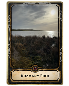
Dozmary Pool lies on Bodmin Moor, south of Bolventor and north east of Bodmin. It is a post-glacial lake, once described as the only natural inland lake in Cornwall, and forms one of the sources of the River Fowey through its outflow towards Colliford Lake. The pool and surrounding area were designated a Site of Special Scientific Interest in 1951 and now lie within the Cornwall National Landscape. Its open moorland setting has made it a place of both ecological and folkloric importance. The pool has long been associated with King Arthur and Excalibur. Later tradition claims that this was the lake where the sword was received from and eventually returned to, the Lady of the Lake. The story became especially popular after the nineteenth century, when Alfred, Lord Tennyson’s Arthurian poetry helped connect Dozmary Pool with the wider legend. Earlier writers often focused more on the pool’s bleakness and local folklore than on Arthur, suggesting that the Excalibur association grew strongly in the Victorian period. Dozmary Pool is also closely linked with the legend of Jan Tregeagle. According to tradition, Tregeagle was condemned after death to carry out impossible tasks, including emptying Dozmary Pool with a leaking limpet shell. His cries were said to be heard across the moor during storms. The belief that the pool was bottomless was common in folklore, but this was disproved when the pool dried out during droughts, revealing its shallow lakebed. The pool has archaeological importance as well as legendary associations. In the nineteenth century, drought exposed large numbers of worked flints around the lakebed, showing Mesolithic activity in the area. These tools provide evidence for early hunter-gatherer communities using the moorland landscape long before later farming, settlement, and folklore developed. The surrounding area also contains traces of prehistoric activity, adding to the wider archaeological value of Bodmin Moor. Dozmary Pool is also significant for wildlife and environmental history. Its sediments preserve evidence of vegetation change since the last Ice Age, while its waters and margins support rare plants such as spring quillwort and six-stamened waterwort. The pool has also been valued for birds, insects, and other wetland species, although its importance has changed since nearby reservoirs were created.

King Doniert’s Stone stands beside the road from St Cleer to Redgate on the edge of Bodmin Moor. The site consists of two granite cross shaft fragments dating to the late ninth century, together with an underground passage and chamber beneath them. The northern fragment is known as the Doniert Stone, while the taller southern fragment is often called the Other Half Stone. Together, they are among the most important early medieval monuments in Cornwall. The Doniert Stone is 1.37 metres high and is decorated with panels of interlaced carving on three sides. On its east face is the inscription “doniert rogavit pro anima,” usually translated as “Doniert has asked for this for his soul” or “Doniert begs prayers for his soul.” The inscription is thought to refer to Dumgarth or Dungarth, a king of Cornwall recorded in the Annales Cambriae as having drowned around AD 875. This makes the stone especially significant, as it is one of the few inscribed stones connected with a Cornish ruler known from written sources. The Other Half Stone stands about 2.1 metres high and remains in situ. It also carries interlaced decoration and has a broken mortise slot at the top, where a cross head or upper element may once have been fitted. Both stones probably formed parts of early medieval crosses and may have marked a sacred site, a routeway, or a place associated with burial and commemoration. Their position overlooking the River Fowey and near an ancient ridgeway adds to their landscape significance. In 1849, excavations around the stones revealed a hidden rock-cut passage and chamber. The passage begins south east of the crosses, turns into a tunnel, and ends in a cruciform chamber beneath the site. Its purpose remains uncertain. Some have interpreted it as an early Christian oratory or vault, while others have argued that it may be connected with ancient tin working. The relationship between the chamber and the crosses has never been fully resolved. King Doniert’s Stone has long attracted history, legend, and speculation. Local tradition links Doniert’s death with the River Fowey and sometimes places it near Golitha Falls, although the details remain uncertain. The Doniert Stone was re erected in 1849 after lying for many years in a pit near the Other Half Stone. Today, the site is managed by Cornwall Heritage Trust and cared for by English Heritage.

Saint Nectan’s Glen, or Glynn Nathan in Cornish, is a wooded valley near Trethevy and Tintagel in north Cornwall. It follows the Trevillet River for around a mile and is best known for St Nectan’s Kieve, a 60 foot waterfall that drops through a natural hole in the rock into a pool below. The glen is now a popular visitor destination, with woodland walks, a café, and access to one of Cornwall’s most distinctive natural features. The site has become strongly associated with spirituality and modern folklore. Visitors often leave ribbons, crystals, photographs, small stone piles, and other offerings near the waterfall. These practices are recent, but they show how the glen continues to attract people seeking reflection, meaning, and connection with the landscape. The waterfall’s dramatic setting, enclosed by rock, trees, moss, and water, has helped shape its modern reputation as a sacred or atmospheric place. Local tradition claims that Saint Nectan lived as a hermit above the waterfall in the sixth century and rang a silver bell to warn ships of danger during storms. This story appears to have developed through later romantic writing rather than firm medieval evidence. The site was recorded in 1799 as Nathan’s Cave, probably named after a local person rather than the saint. Nearby Trethevy does have religious associations, including remains connected with a small chapel dedicated to St Piran, but the direct link between the waterfall and Saint Nectan is uncertain. In 2025, reports of a horned skull found by a visiting family brought new attention to the glen. The find was quickly drawn into local and Arthurian storytelling, with some calling it “Merlin’s unicorn.” There is no firm evidence that it represents anything mythical, but the story shows how new discoveries can be absorbed into the folklore of a place. Like the older saintly legends, this modern tale adds another layer to the glen’s changing identity. Saint Nectan’s Glen is also important for its wildlife and ecology. It was designated a Site of Special Scientific Interest in 1985 because of its rich plant life, especially mosses and liverworts that thrive in the damp shade of the valley. Rare species grow in the humid conditions, and dippers nest among the rocks near the waterfall. Today, the glen brings together natural history, modern spiritual practice, local legend, and the long appeal of Cornwall’s wooded river valleys.

The Tristan Stone stands beside the road into Fowey, a weathered granite shaft carrying one of Cornwall’s most evocative early Christian inscriptions. Known over time as the Longstone, Castle Dore Stone, Cunomorus Stone, and now most commonly the Tristan Stone, it has survived with remarkable clarity. Its Latin inscription, usually read as “Drustanus lies here, son of Cunomorus”, has drawn the attention of antiquaries for centuries, not only because of its age, but because of the names it may preserve. The stone is thought to have begun life as an early Christian memorial, probably dating somewhere between the fifth and eleventh centuries. On one face is the inscription, cut in two vertical lines, while the opposite face carries a rare relief Tau cross, a T shaped Christian symbol. At some later point, a socket was cut into the top of the stone to hold a cross head, changing it from a memorial into a wayside cross. Even without its head, it still speaks of the long life of old routes, sacred markers, and Cornish places where memory gathered by the roadside. Its fame rests partly on the possibility that Drustanus and Cunomorus may be remembered in later legend as Tristan and King Mark. With Castle Dore lying nearby, some have linked the stone to the world of Tristan and Iseult, the doomed lovers whose story passed through medieval romance, poetry, and music. Certainty remains out of reach, but that is part of the stone’s power. It stands at the meeting point of inscription, landscape, and legend, where an early medieval name carved into granite may have grown into one of Europe’s great tragic love stories. The Tristan Stone has not been left undisturbed. It has been moved more than once, and in recent years its relocation for development provoked anger from those who saw the act as a wound to Cornwall’s cultural inheritance. That feeling has deep roots. Carew’s seventeenth century account tells of treasure seekers trying to dig beneath the stone by moonlight, only to be driven away by storm, thunder, and fear. It is a familiar Cornish warning: disturb the old stones at your peril.

The Artognou Stone was discovered during excavations at Tintagel on Cornwall’s north coast. It is a small slate slab, measuring about 35 by 20 centimetres, but it has become one of the most discussed finds from the site. The stone was found near early medieval building remains in a sealed archaeological layer, giving rare physical evidence for activity at Tintagel during the post Roman period. Its importance comes from its inscriptions and from its discovery in a place long associated with Arthurian legend. The stone appears to carry more than one inscription. One area includes a possible Christian symbol, with a diagonal cross, Alpha and possibly Omega, and a Chi in the centre, forming what may be a Christogram. Another inscription is scratched more lightly and reads in part “PATERN[--] COLI AVI FICIT ARTOGNOU.” This has often been interpreted as meaning that Artognou, a descendant of Paternus Colus, made it. The informal nature of the carving suggests that it may have been graffiti rather than a formal memorial. The name Artognou has attracted particular attention because of Tintagel’s association with King Arthur. The Brittonic name is usually interpreted as meaning something like “Bear Knowing,” from words connected with bear and knowledge. Although this led to popular claims that the stone was an “Arthur Stone,” scholars have rejected a direct link between Artognou and Arthur. The name Arthur is generally treated as linguistically separate, so the stone should not be taken as evidence for the historical Arthur. The wider archaeological context is still highly significant. Excavations at Tintagel revealed imported pottery, glass, and other material from the Mediterranean and western Europe, including links with Byzantium and Visigothic Spain. These finds suggest that Tintagel was a place of wealth, trade, and high status in the fifth and sixth centuries. Rather than an isolated headland, it appears to have been an important centre within the early medieval kingdom of Dumnonia. The Artognou Stone is an important find because it connects writing, Christianity, trade, and identity at Tintagel during a poorly documented period. Its inscriptions do not prove the presence of Arthur, but they do show that literate people were active at the site in the early medieval period. Whether Artognou was a visitor, resident, scribe, or person commemorated by others remains uncertain. The stone remains valuable because it gives a rare glimpse into the real post-Roman world that later helped shape the legends of Tintagel.

Merlin’s Cave is a natural sea tunnel beneath Tintagel Castle on Cornwall’s north coast. It runs through the rock below Tintagel Island, linking Tintagel Haven on the eastern side with West Cove on the western side. At low tide, it is possible to walk through the cave along its sandy floor, but at high tide the tunnel fills with seawater and becomes impassable. The cave is about 100 metres long and was formed by marine erosion along a line of weakness between slate and volcanic rock. The cave takes its name from Merlin, the wizard of Arthurian legend, but this association is much later than the medieval stories themselves. Tintagel became linked with Arthur in the twelfth century through Geoffrey of Monmouth, who described it as the place where Arthur was conceived after Merlin disguised Uther Pendragon so he could enter the chamber of Igraine. However, medieval Arthurian texts do not describe Merlin as living in a cave at Tintagel. The name Merlin’s Cave appears to have developed in the late nineteenth century, during the Victorian revival of Arthurian literature. Alfred, Lord Tennyson’s Idylls of the King helped reshape the popular image of Arthur’s origins, including the idea of the infant Arthur being carried by the sea and found by Merlin. Later writers and visitors connected this imagery with the sea cave beneath Tintagel Castle, and the name gradually became established in guidebooks, maps, and tourism. The cave and nearby cove may also have had practical importance in the early medieval period. From the fifth to seventh centuries CE, Tintagel was a high status site with evidence of trade links across western Europe and the Mediterranean. Imported pottery and other finds from the area suggest that goods may have been landed in the sheltered cove below the castle. The cave itself is tidal, so there is no firm evidence for long term occupation inside it, but the surrounding shoreline was likely part of Tintagel’s working coastal landscape. In 2015, English Heritage added a carved figure of Merlin near the cave entrance as part of its interpretation of Tintagel’s legendary associations. The sculpture received mixed responses, with some visitors welcoming it and others criticising it as an overemphasis on myth at an important archaeological site.
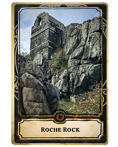
Roche Rock, or An Garrek in Cornish, is one of the most distinctive landmarks in Cornwall’s clay country. The dark rock outcrop rises about 20 metres above the surrounding landscape near the village of Roche, whose name comes from the French La Roche, meaning “the rock.” Geologically, it is a fine example of quartz schorl, a fully tourmalinised granite rich in black tourmaline crystals. The site was designated a geological Site of Special Scientific Interest in 1991 because of its importance for understanding the St Austell granite and its mineral history. On top of the rock stands the ruined chapel of St Michael, built in 1409 by the Tregarrick family. The small two storey building was constructed from local granite and fitted closely into the natural shape of the outcrop. The lower level may have served as a cell or living space, while the upper floor formed the chapel itself. Although now roofless and ruinous, the surviving walls, windows, and doorways show the skill of its medieval builders. Roche Rock may once have been a place of pilgrimage, with a beacon lit on the heights to guide travellers across the surrounding moorland. Roche Rock is closely tied to folklore. One tradition links it with the priest Ogrin, who in some versions of the Tristan and Iseult story gives shelter and counsel to the lovers as they flee King Mark. Another story claims that the chapel was once home to a leper, sometimes identified as Sir John Tregarrick, who withdrew from the world and was cared for by his daughter. Nearby Saint Gundred’s or Gunnett’s Well also developed its own legends, including claims that its water ebbed and flowed like the sea or was connected by a tunnel to St Austell Bay. The rock also appears in darker Cornish traditions. It was said to be a gathering place for witches and a refuge for Jan Tregeagle, the doomed magistrate of Cornish legend. After death, Tregeagle was condemned to impossible tasks and pursued across the moors by the hounds of hell. In one version, he escaped into the chapel at Roche Rock because the hounds could not enter holy ground. His cries were said to be heard in the wind, adding another layer to the rock’s reputation as a place of fear, punishment, and supernatural protection. Roche Rock also has a more recent history of public access and local protest. In the late nineteenth century, Lord Falmouth attempted to assert ownership by fencing the site and restricting entry. Local opposition followed, and in 1898 an iron noticeboard was blown up with dynamite. The dispute was eventually resolved by allowing public access for most of the year.

Carbilly Tor is a natural rock formation on Bodmin Moor, standing about 100 metres north east of the old quarry chimney stack near the former works. It is also sometimes referred to as Arthur’s Sword in the Stone, though this name appears to come from a modern theatre group developing an Arthurian play rather than from older folklore. The rock stack is around 10 metres high and can be reached on foot, although climbing onto the capstone is difficult and potentially dangerous. The formation has a striking appearance and can look almost deliberately built, but it is probably natural. The capstone has possible weathered markings that some have interpreted as a carving, including a raised form with a channel running down the southwest side into a vertical groove and a hollow in the base rock below. These features may be natural erosion, but they have encouraged speculation about whether the site was ever noticed or altered by people in the past. The stack is also pierced through, and from the opposite hill on the St Breward road, a cross-like opening can be seen in the rock. Local enquiries have not yet produced clear references to the formation in older books or records, and it does not appear to have a well-documented antiquarian history. Its interest lies mainly in its unusual geology, its possible markings, and the way a modern Arthurian association has developed around a dramatic natural feature in the moorland landscape.

The Battle of Camlann is one of the most important events in Arthurian legend. In Geoffrey of Monmouth’s History of the Kings of Britain, it is the final battle between King Arthur and Mordred, who is described as Arthur’s treacherous nephew. The battle is said to have taken place near the River Camblam in Cornwall, ending with Mordred’s death and Arthur being mortally wounded. In the legend, Camlann marks the end of Arthur’s rule and the beginning of the decline of Brittonic power in Britain. The site most often linked with Camlann in Cornwall is Slaughterbridge, near Camelford. Here, the River Camel runs through meadows long associated with Arthur’s last battle. The place name Camelford has sometimes been connected with the Cornish “cam pol,” meaning a crooked or curved river, although the link with Camlann remains uncertain. Even so, the landscape around Slaughterbridge has become one of Cornwall’s most enduring Arthurian locations. Near the supposed battlefield stands the inscribed stone often called Arthur’s Stone. It is a tall memorial stone, over 9 feet high, and is usually dated to the sixth century. The inscription is fragmentary and has been debated for centuries. Some readings interpret it as referring to Latinus, son of Magarus or Macarus, while others have suggested a more speculative reading connecting it with Arthur. The stone does not prove the existence of King Arthur, but its early medieval date makes it an important monument in its own right. The stone was first recorded by Richard Carew in the seventeenth century and has since attracted antiquarian and popular interest. Its Latin inscription, and possible association with early medieval Cornwall, have helped link the site with wider debates about whether Arthur was based on a real historical figure. The presence of ogham has also been claimed in some accounts, although interpretations vary. What is clear is that the stone belongs to the same broad period in which a historical Arthur, if he existed, might have lived. The area around Slaughterbridge remains rich in Arthurian tradition. Local stories include the battlefield meadows, nearby Worthyvale, and tales of the Wild Hunt, with Arthur imagined leading ghostly hounds along the lanes on stormy nights. Modern interpretation at the Arthurian Centre has helped keep these stories alive for visitors.

The Battle of Camlann is one of the most important events in Arthurian legend. In Geoffrey of Monmouth’s History of the Kings of Britain, it is the final battle between King Arthur and Mordred, who is described as Arthur’s treacherous nephew. The battle is said to have taken place near the River Camblam in Cornwall, ending with Mordred’s death and Arthur being mortally wounded. In the legend, Camlann marks the end of Arthur’s rule and the beginning of the decline of Brittonic power in Britain. The site most often linked with Camlann in Cornwall is Slaughterbridge, near Camelford. Here, the River Camel runs through meadows long associated with Arthur’s last battle. The place name Camelford has sometimes been connected with the Cornish “cam pol,” meaning a crooked or curved river, although the link with Camlann remains uncertain. Even so, the landscape around Slaughterbridge has become one of Cornwall’s most enduring Arthurian locations. Near the supposed battlefield stands the inscribed stone often called Arthur’s Stone. It is a tall memorial stone, over 9 feet high, and is usually dated to the sixth century. The inscription is fragmentary and has been debated for centuries. Some readings interpret it as referring to Latinus, son of Magarus or Macarus, while others have suggested a more speculative reading connecting it with Arthur. The stone does not prove the existence of King Arthur, but its early medieval date makes it an important monument in its own right. The stone was first recorded by Richard Carew in the seventeenth century and has since attracted antiquarian and popular interest. Its Latin inscription, and possible association with early medieval Cornwall, have helped link the site with wider debates about whether Arthur was based on a real historical figure. The presence of ogham has also been claimed in some accounts, although interpretations vary. What is clear is that the stone belongs to the same broad period in which a historical Arthur, if he existed, might have lived. The area around Slaughterbridge remains rich in Arthurian tradition. Local stories include the battlefield meadows, nearby Worthyvale, and tales of the Wild Hunt, with Arthur imagined leading ghostly hounds along the lanes on stormy nights. Modern interpretation at the Arthurian Centre has helped keep these stories alive for visitors.

Lyonesse is one of the most dramatic legends connected with Cornwall. It is usually described as a lost land that once lay between Land’s End and the Isles of Scilly, before being swallowed by the sea in a great flood. Later accounts describe it as a prosperous kingdom with villages, fields, roads, and 140 churches. Although there is no proof that such a kingdom existed, the story has remained powerful because it brings together folklore, coastal change, local identity, and the idea of a vanished world beneath the waves. The legend became closely aligned with Arthurian literature. In Sir Thomas Malory’s Le Morte d’Arthur, Lyonesse is named as the home of Sir Tristram, the Cornish knight whose story is tied to love, loyalty, and tragedy. Alfred Lord Tennyson later gave Lyonesse an even stronger place in the Arthurian imagination through Idylls of the King, where it becomes the setting for Arthur’s final battle with Mordred. Older Cornish accounts also helped define the legend. William Camden’s Britannia, published in 1586, recorded stories of a drowned land near Cornwall, while Richard Carew’s Survey of Cornwall, published in 1602, referred to Lethowsow, meaning the submerged lands. Carew also linked the story to the Trevelyan family, whose arms are associated with a horse escaping the flood. These early references suggest that stories of lost land and drowned places were already part of Cornish tradition before the Victorian revival made Lyonesse more widely known. The story also has a connection with real changes in the landscape. Submerged forests have been recorded around the Cornish coast, including ancient tree remains exposed at very low tides in Mount’s Bay. Geological studies also show that the Isles of Scilly were once part of a larger landmass, later reshaped by rising sea levels after the last Ice Age. This does not prove the existence of Lyonesse as a kingdom, but it does show why stories of drowned land could have taken root in coastal communities that lived with visible evidence of environmental change. Victorian writers such as Thomas Hardy and Walter Besant helped keep the legend's fire burning, while later artists, poets, musicians, and storytellers have continued to reinterpret it. Today, Lyonesse can be read as folklore, literature, environmental tragedy, and Cornish cultural identity. Whether Lyonesse is a myth, history, or a combination of both, it is one of Cornwall’s most compelling stories of a world lost to the sea.

Castle Dore, near Golant in Cornwall, is an important Iron Age hillfort. It is a roughly circular defended enclosure measuring about 79 metres across, with two defensive ditches and associated ramparts. These ramparts were built from earth dug from the ditches and were later heightened. The site was probably occupied from the fifth or fourth centuries BCE until the first century BCE. Major excavations were carried out in the 1930s by C. A. Ralegh Radford, making Castle Dore one of the most extensively investigated Iron Age hillforts in Cornwall. Radford examined both the defences and the interior of the fort. His work uncovered postholes showing at least two main phases of occupation and evidence for around twenty roundhouses. These findings helped establish Castle Dore as a significant settlement site rather than simply a defensive enclosure. Radford initially suggested that the fort had been reused in the fifth and sixth centuries CE. He identified a timber hall within the site and linked it with King Mark of Cornwall, a figure associated with the Tristan legend. Later reassessment has challenged this interpretation. Pottery evidence and wider archaeological study now suggest that the main occupation belongs to the Iron Age, with construction in the fifth to fourth centuries BCE, later changes to the entrance, and probable abandonment before the Roman period. Castle Dore also has an important place in Civil War history. In August 1644, during the Battle of Lostwithiel campaign, Parliamentarian forces under the Earl of Essex retreated into the ancient earthworks while being pursued by Royalist armies. The position was eventually surrounded, and the Parliamentarian army was forced to surrender. This event contributed to the site’s recognition as a registered battlefield and shows how the old hillfort retained strategic value long after its prehistoric use had ended. Today, Castle Dore is a scheduled monument and remains an important site for understanding Iron Age Cornwall, later antiquarian interpretation, Arthurian associations, and Civil War history. It can be reached by a short walk from a lay-by on the B3269, although care is needed because of traffic. The site is privately owned, with informal access. Its wider landscape also includes links with the Tristan Stone and traditions of King Mark, adding a further layer of legend to its archaeological and military importance.
